
The Carretera Austral, also known as Route 7, is one of the most iconic and adventurous routes in South America. This route, extending over 1,200 kilometers, takes you past fjords, volcanoes, glaciers, impressive mountains, and mountain lakes. It's a popular route to drive with your own transport, as the distance is manageable and it offers an unparalleled mix of diversity and adventure. Although it's a well-known route, it provides the opportunity to discover beautiful, secluded spots in addition to visiting national parks. Here, you have the chance to wild camp in some of the most beautiful locations. We have made wonderful memories here and look forward to sharing everything in this blog.
THE ROUTE
The idea to connect the remote parts of Southern Chile with the rest of the country emerged in 1970. This was a challenging construction project due to the rugged terrain, characterized by fjords, rivers, and mountain ranges. As the Carretera Austral was completed and became more accessible, it began to attract more travelers who wanted to explore the pristine nature and landscapes. The Carretera Austral starts in the city of Puerto Montt, located in the south of Chile. From there, the road heads southward through the beautiful and remote areas of Patagonia, ending in Villa O'Higgins.

To this day, work continues on improving the roads. Therefore, it's possible that you'll encounter roadworks along the way, which can cause some delays. However, this also means that road conditions are improving each year. The stretch from Puerto Montt to Cerro Castillo is mostly paved, but beyond that, the road is mainly unpaved tracks. Detours to Futaleufú and the San Rafael Glacier are also unpaved and therefore take more time to reach. We ourselves drove in a Mercedes Sprinter van, not a 4x4, but were still able to get everywhere. It is advisable to drive more slowly and allocate more time for the journey.

TRANSPORT
If you have more than three months to travel around Chile or Argentina, you might consider buying a car or van and then selling it later. This process is relatively straightforward and can save a lot of money over a longer travel period! We bought a van in the capital of Chile and drove this route, among others. A blog dedicated to purchasing your own vehicle in Chile will be coming soon.

If you are traveling for a shorter period, you can take the bus, hitchhike, or rent your own transport. Public transport is a good, cheap option, especially in the high season (December to March), when buses frequently run between the towns. It's best to check recent bus schedules upon arrival so you can plan and possibly make reservations for your next leg. Transport varies from large luxury buses to small vans with little legroom, and prices vary accordingly. A downside is that not all villages are connected to the national parks, so sometimes you might need to hitchhike to get there. Regarding hitchhiking, it is very common on this route. We have picked up travelers almost daily. Of course, you are dependent on people's willingness to take you, but if you have the time, it's a fun, cheap, and on this route, safe way to travel.


If you want the freedom to go wherever you want and you don't have much time, then renting transportation is the best option. The Carretera Austral officially starts in Puerto Montt, but we found Puerto Varas, 40 kilometers further north, to be much more enjoyable. In both places, you can rent a car or van to drive this route. If you're planning a trip in the high season, it's necessary to book in advance! Well-known companies for renting vans or 4x4s with roof tents include Condor Camper and Wicked Campers. For renting regular cars, there are many companies in both towns. It's cheaper to return the vehicle at the same place, but for an additional fee, you have the option to, for example, drop it off in Punta Arenas if you plan to travel further south.
If you'd prefer not to arrange your own transport, an organized tour is a good option. These are often more expensive, but everything is arranged and included. For instance, GeoTerra offers a six-day trip along the highlights of the Carretera Austral.
TRAVEL TIME
Since we had plenty of time, we could afford to decide on a daily basis what to do without a fixed schedule. We made extensive use of the iOverlander app to gather useful information about the route and discover great camping spots. The route can be completed in two weeks with good planning. For those who want a bit more freedom to stay longer at certain places, three weeks is ideal. It took us 19 days to travel from Puerto Montt to Cochrane. From there, it's another small five-hour drive to Villa O'Higgins. Since we wanted to cross the border into Argentina at Chile Chico, a small town just to the north, and because the roads from Cochrane were deteriorating, we decided to turn back and end our Carretera Austral adventure there.
The Carretera Austral can be difficult to navigate during the winter months due to snow and adverse weather conditions. The best time to travel the road is during the summer months, from around November through March.

OUR STOPS
Puerto Varas
As mentioned earlier, we found Puerto Varas to be much more enjoyable than Puerto Montt. Therefore, it's worth considering spending a night here instead of in Puerto Montt, if it fits your schedule. The first step is to take a short ferry from La Arena to Caleta Puelche; current times and prices can be found on this website. This ferry operates very frequently, so advance reservations are not possible; tickets are purchased on site. Once arrived in Caleta Puelche, it's about an hour's drive to Hornopiren, where you take the next ferry to Galeta Gonzalo. This ferry ride lasts 3.5 hours and sails less frequently. Therefore, in the high season, it's advisable to book your ticket in advance, which can be done via this website or at the ferry operator's office in Puerto Montt. The operator's office, Somarco, is located here. We were lucky and could board the next day, but we met travelers who had to wait a week for a spot.

Parque Nacional Pumalin
The first stop is Chaitén, home to Pumalín National Park, where the Chaitén volcano dominates the landscape. This volcano erupted in 2008, completely destroying the nearby village of Chaitén. Images of this eruption can be seen at the start of the hiking trail to the volcano. The hike is 4.8 kilometers long with an elevation gain of about 600 meters; on average, it takes about 3 hours to complete there and back. The trail leads to a viewpoint on the crater rim, from which, weather permitting, you have a view of the impressive volcanic caldera with a diameter of about 3 kilometers. A volcanic caldera is a large, bowl-shaped depression in the earth's surface that forms after a powerful volcanic eruption, where the top of the volcano collapses, leaving behind a large, round or oval pit.


Another attraction in this park is the Michinmahuida volcano, covered with a glacier. We walked the Sendero Mirador Glaciar Michinmahuida, a hiking trail through dense forest leading to a viewpoint overlooking the volcano and the hanging glacier. This route is 6.8 kilometers long and takes about 2.5 hours to complete. However, the photo shows that the point you walk to is still quite far from the glacier.


Futaleufú
The second stop on our journey was Futaleufú, locally known as 'Futa'. On our way there, we stopped at the Ventisquero Yelcho trail. This is a short and easy hiking route of 6.1 kilometers that takes you through the forest to a viewpoint with a beautiful view of the Ventisquero glacier.
Futaleufú is a place where you can easily spend several days. The village is located in the Andes, surrounded by mountains, forests, lakes, and rivers. The most famous river is the Futaleufú, renowned for its turquoise waters and known as one of the best rivers for whitewater rafting. The road to Futaleufú is largely unpaved. Since we had to deal with a lot of dust in our bus, we decided to stop along the way and camp at one of the most beautiful wild camping spots of the entire trip.

Futaleufú is a small village with very friendly people, supermarkets with basic products, and a number of cozy restaurants and cafes. We stayed at El Amigo Patagon camping, a place we definitely recommend! We were there when they were not officially open yet and were still in the process of building a communal area and kitchen. The owner is very helpful; they have hot showers, a nice communal area, and kitchen.
A must-do activity for adrenaline seekers is whitewater rafting! We went with Bochinche Expediciones, and it was truly an amazing experience. They create a pleasant atmosphere, work with experienced staff, and all their boats and equipment are of good quality. You ride a bus to the starting point, where you first receive instructions before going onto the water in small groups, or in our case, just the two of us. On the water, it's a fantastic experience; you navigate through waves and currents in a beautiful setting. They provide homemade snacks and drinks for after the rafting.


In the area around Futaleufú, you can also make beautiful hikes. We highlight three hiking trails that we recommend. The first is Piedra del Aguila, a short but steep hike of 4.3 kilometers with a magnificent view of the valley, mountains, and alpine lakes. The hike starts on private property, a 10-minute drive from Futaleufú. There was nobody there when we were, but a small entrance fee might be requested.
The second hike is Miradores Río Futaleufú y el Cóndor. The farthest viewpoint is 2.5 kilometers from the start and offers a panoramic view of the Futaleufú River and the valley. You really realize how beautiful the surroundings are here. From Futaleufú, it's a fifteen-minute drive to the entrance of the national reserve at the ranger station, where you register before starting the hike.

The third hike, our favorite, is called Lago las Rosas and is relatively unknown. We received this tip and are happy to share it. You drive about 10 minutes to the starting point of this 20-kilometer-long hike. The first part gently ascends through the forest, and at the top, the trail follows along a large azure blue mountain lake before descending to a smaller lake. The hike has some ascents but is manageable and not technically difficult.


Puyuhuapi
The stop after Futaleufú was Puyuhuapi. We stayed here before continuing to Queulat National Park. A beautiful wild camping spot that we think is worth sharing. Puyuhuapi is also a small village with a basic camping site, a few places to stay, and a couple of restaurants.

Parque Nacional Queulat
Along Route 7 is Queulat National Park, famous for its striking geographical features, including the Ventisquero Colgante, a hanging glacier. It's important to know that upon arrival, you must show an e-ticket. This ticket must be purchased in advance through this website. We took the risk of trying to buy a ticket on-site but were sent away to a nearby campground with Wi-Fi to purchase the ticket online. From the main entrance of the park, there are four short hikes available. Two of these we definitely recommend:
Mirador Ventisquero Colgante - 5.6 kilometers - offers a stunning view of the hanging glacier and its waterfall.
Sendero Laguna Tempanos - 1.3 kilometers - takes you to the lake where the waterfall flows into. From here, you can also take a boat trip to the glacier.


Coyhaique
The first major city on the route is Coyhaique. The journey from Queulat National Park to Coyhaique is magical and invites multiple stops. In Coyhaique, we stayed at 'El Camping', a fantastic city campsite with plenty of space, excellent Wi-Fi, clean sanitary facilities, and a cozy communal area. Coyhaique is a fun city to explore in a day and do your shopping. Additionally, the city offers a wide range of restaurants. We recommend CB Gastronomia, where you can eat gourmet food at a reasonable price. Basilic Bistro, a cozy vegetarian bar that serves delicious pastries, is also worth a visit.


Parque Nacional Cerro Castillo
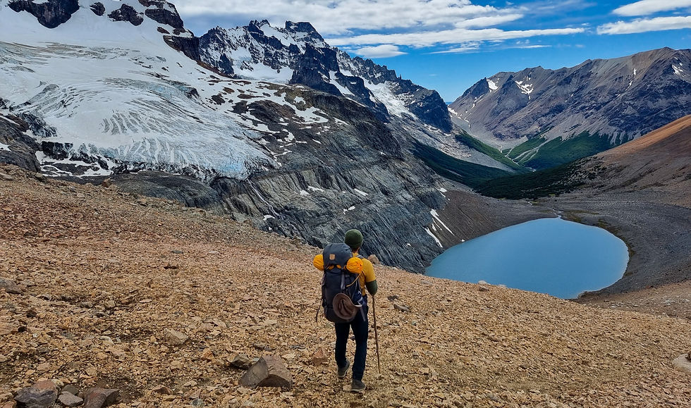
After Coyhaique, our next stop on the Carretera Austral was the village of Castillo. Although small, the village offers some basic amenities such as accommodations, restaurants, and small shops. Adjacent to the village is the main attraction for many tourists: Cerro Castillo National Park. The mountain of the same name, Castillo, dominates the landscape as a natural icon with its snow-covered peaks and rugged contours. We camped in the national park's parking lot, packed our backpacks, and headed into the mountains for two days. We would have liked to spend at least three days in the park, but some trails were still closed at the end of December due to snow. It's hard to put into words how beautiful it is, so we'll let the photos speak for themselves!
We will soon publish an extensive blog dedicated to the multi-day hike in Cerro Castillo.


Puerto Rio Tranquillo
As mentioned before, this route is a continuous sequence of natural wonders. Our next stop after Cerro Castillo was Puerto Rio Tranquillo, home to the Marble Caves. These marble caves are known for their unique and beautiful marble formations, shaped by the long-term action of the lake's water on the limestone. The formations range from white to deep blue, creating an enchanting play of colors and reflections. Puerto Rio Tranquillo itself is a small village with a few basic amenities and many travel agencies offering tours to the caves. Since they all offer similar tours, it doesn’t matter much which provider you choose. You can opt for a boat trip or a kayak trip to the caves. We chose the kayak trip, and it was a beautiful and impressive experience. Along with a guide, you go to a location where you get into the kayaks, and from there, you paddle for about 20 minutes to the caves. At the caves, the guide shares his knowledge, and you get time to paddle around and through the caves.
The major difference between kayaking and the boat tour is that the boat tour rushes you through everything, whereas kayaking gives you all the time you need to paddle around the marble caves.

Confluence of Baker River and Neff River
A height difference of over 10 meters creates a striking waterfall where the Baker River and the Neff River converge. At this spot, you can see the contrast between the turquoise blue water of the Baker River and the murky water of the Neff River. The Neff River, approximately 30 kilometers long, originates in the Campos de Hielo Norte and flows into the Baker River. Its characteristic milky color is a result of the glacier-fed tributaries and snowy mountains. The Baker River, stretching 200 kilometers, flows with its turquoise blue water from Lake Bertrand to the sea at Caleta Tortel. It's truly a spectacular sight and well worth a stop. You can find the exact location here on Google maps.

Parque Nacional Patagionia
Douglas Tompkins and his wife Kristine were prominent conservationists who made a significant contribution to the preservation of the Patagonian wilderness. After a successful career in the fashion industry, the couple dedicated themselves to environmental conservation from the 1990s onwards. Together, they founded Tompkins Conservation and acquired vast tracts of land in Patagonia. In 2004, Douglas donated a large portion of this land to the Chilean government, leading to the creation of the new Patagonia National Park, consisting of the Tamango National Reserve, Jeinemeni National Reserve, and Patagonia Park.
The park has three entrances: the towns of Cochrane and Chile Chico, and the park headquarters in the Chacabuco Valley. We visited the park from the headquarters in the Chacabuco Valley.


An unpaved road leads from Ruta 7 to the visitor center of Patagonia National Park. This road is beautiful, and along the way, you can often spot guanacos and, with a lot of luck, a puma. The visitor center is impressively equipped. In contrast to other national parks, you'll find a reception desk, an interactive museum, a café, and a restaurant here. The museum, with free admission, is definitely worth a visit. You can learn about the history, flora and fauna, and the importance of nature conservation there.

You can purchase park entrance tickets online through this website or at the reception desk in the visitor center. We bought our tickets at the visitor center and also reserved two different camping spots in the park. In our blog dedicated to this unique national park, we provide information about the various entrances, campgrounds, and hiking trails.
These were all the places we visited during our journey along the Carretera Austral. Do you have any questions, or do you know of a place that is also worth mentioning? Feel free to send us a message in the chat!
תגובות